SOLUTION
A much faster 2d model H_SIM-2d, as developed by us.
The model H_SIM-2d brings the following advantages:
-
More detailed modeling of the flood or flood hazard areas.
- Raster data is (for the most part) adopted in their original form for the 2d modeling, so that no data loss occurs through thinning and thus the intersection of the result data (WSPL) with the terrain is carried out more precisely and without or with minimal interpolation.
- The numerical error decreases in most models practically quadratically (i.e. 2nd order of accuracy) with decreasing point spacing and is therefore significantly reduced .
- With high-resolution meshes consisting of triangular and square elements with a mesh spacing between approx. 0.5 m to 1 m or a maximum of 2 m, a kind of standard is created and thereby the quality assurance is significantly increased . This means that we no longer have to deal with the subject of sufficient discretization and mesh quality because the space between points is very small and the mesh is relatively homogeneous.
- The task will be much easier for both the model creator (contractor) and for the WW authorities (client). The high-resolution models created in this way will also increase the general acceptance among the affected citizens and significantly increase the credibility of the model results in the event of court dispute.
- The risk of creating inadequate models is significantly reduced by using high-resolution models.
-
Fast operational models with relatively fine resolution even for larger areas.
- Due to the short calculation time , a majority of the existing 2d models can be used for the real-time simulation or can be used directly for operational use.
- Long-term simulations of longer flow sections, especially in connection with sediment transport modeling, becomes reality.
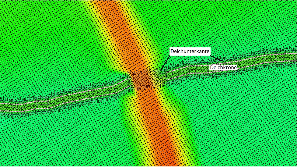 High-resolution mesh: structures such as levee courses are correctly reproduced by the mesh.
The number of points on the top of the levee (4 to 5) is sufficient for precise modeling.
Our conclusion : The modeling strategy developed at that time (10 - 20 years ago) was undoubtedly optimal and correct with regard to the computing speed back then. Nowadays, in view of the new, much faster models and existing computing capacities, such an approach is no longer up-to-date and is now difficult to convey.
Use our innovative state of the art software for the effective solution of your problems. Increase the quality assurance of your created models and reduce the risk of creating defective models to a minimum.
Our motto is : we not only create beautiful pictures and beautiful animations, but we model reality in great detail and very precisely.
Our newly developed software H_SIM-2d is at least as precise and as robust as our previous software HYDRO_AS-2D, Hydro_GS-2d, Hydro_FT-2d, Laser_AS-2D, etc.
More information about H_SIM-2d can be found here .
Contact us, we are happy to answer all your questions: office@ib-nujic.de